
Where a fact is unavailable, the page says so. Readers considering Adarsh Urbanite can also compare Prestige Oakville, which is an upcoming Prestige project of 226 three- and four-bedroom homes in Koramangala 1st Block. Address Maker Apollo is useful for the same-city location lens because the real test is weekday travel, school runs, healthcare access, and how the approach road feels at peak hours.
Adarsh Urbanite Address
| Field | Value |
|---|---|
| Street address | Yemalur and Bellandur Amanikere villages, Bellandur Lake Road, Varthur Hobli, Bengaluru East Taluk |
| Locality | Bellandur |
| City | Bengaluru |
| State | Karnataka |
| PIN | 560103 (taken from the postal boundary; no project document states one) |
| Latitude, longitude | 12.940892, 77.680814 |
| Country | India |
The map link built from the coordinates is https://www.google.com/maps/search/?api=1&query=12.940892,77.680814.
Three points on the address deserve care.
- The PIN is derived from the postal boundary and is not printed on an official document. Treat it as a working reference and confirm it when official papers, such as a K-RERA registration, become available.
- The address is expressed in land-record terms (villages, hobli and taluk) rather than as a street number. The project is pre-launch, and no postal address from a registration was available as at 30 September 2026.
- A verified registered project name and registration address are not yet available. K-RERA registration is pending as at 30 September 2026; later status has not been confirmed. Ask for the current entry and compare its project name, promoter and land description with this page. An address on a later document may be worded differently from the land-record address above.
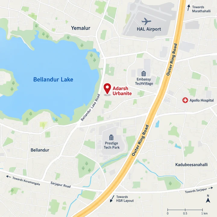 View on Google Maps →
Apartments on Bellandur Lake Road
The site is on Bellandur Lake Road and lies across that road from Bellandur Lake, which is to the west. That relationship is also the subject of one of the illustrations, captioned: “Adarsh Urbanite aerial view across Bellandur Lake Road from Bellandur Lake, artist's impression.” The image is an illustration only. It is not a photograph and not an approved plan, so it should not be used to judge distances, heights, view lines or the exact shape of the land.
The location is East Bengaluru, in the locality of Bellandur. The land is in Yemalur and Bellandur Amanikere villages, which is why the address text includes both names.
What the Site Looks Like on Paper
The cleared plan gives the following about the land itself.
| Item | Value |
|---|---|
| Land | 79,494.32 sq m, about 19.6 acres |
| Green belt | Includes 24 guntas of public kharab kept as green belt |
| Towers | 7 towers in 18 blocks, ground plus 13 upper floors over one or two basements |
| Maximum height | 44 m (41.9 m for Towers 1 and 2) |
| Buildings | About 19% of the net site area |
| Landscaping | About a third of the net site area |
| Park | About 7,717 sq m |
| Internal driveways | 8 m |
The acreage is a derived conversion: 79,494.32 sq m divided by 4,046.86 sq m per acre is about 19.64 acres, rounded to about 19.6 acres. The project also has 1,109 homes in total: 1,008 apartments of 2.5 and 3 BHK plus 101 EWS homes. For what each part of the layout contains, see the master plan page.
No figure for the net site area in square metres is available, so the percentages above cannot be converted into areas here. The position of the park, the clubhouse and the tower blocks within the land is a matter for the sanctioned plan, which was unavailable as at 30 September 2026.
Adarsh Urbanite East Bengaluru: Local Context
The Bellandur and Outer Ring Road belt is one of Adarsh Developers' core markets. In that belt it lists Adarsh Palm Retreat (a township the developer dates to 2005), Lakefront and Mayberry (Palm Retreat-branded apartments in Bellandur, still listed as ongoing), Rosewood at Doddakannelli village and Parkland at Panathur village. These are the developer's other projects, and facts about them are not facts about Adarsh Urbanite. They are mentioned only because they place the developer in the same part of the city. Details are on the about the builder page.
The label “Adarsh Bellandur” is used for several of the developer's Bellandur projects, so a search for that phrase may return other projects. This page uses the name Adarsh Urbanite and the address above to keep the project distinct.
Beyond that, no market data, price comparisons or competitor information are available, and none is asserted.
Lake and Storm-Water Drains
Storm-water drains shape the land: a primary drain runs along the southern edge with a 50 m buffer, and tertiary drains cross the site with 15 m buffers. The full clearance conditions are not reproduced here. Ask how the current documents address drainage, tree cover and flood precautions, and request the relevant pages. The park illustration is captioned “Adarsh Urbanite park, artist's impression.” Its description refers to lawns and trees beside a planted drain buffer; it remains an illustration, not evidence of the sanctioned arrangement.
The statements above should be checked against the environmental clearance document, which was granted on 16 April 2025. The proponents and landowners named on that clearance are Adarsh Ecstasy Projects Private Limited and Adarsh Developers.
Reasonable questions for the developer are these. How are the drain buffers and the lake-side setting reflected in the sanctioned plan? Which approvals address them? Do the buffers affect where towers, the park or the basements can be placed? Ask for the clearance letter, the sanctioned plan and any drainage or flood-related conditions in writing.
A Deccan Herald item of 15 September 2022 reported BBMP officials as saying that two other Adarsh projects had encroached on storm-water drains. No outcome was found. That item does not concern Adarsh Urbanite. It is mentioned only because buyers near lakes often ask about drains, and it should be weighed in proportion. See the about the builder page for context.
Why Distances Are Not Listed
Distances and travel times were unavailable in the supplied information as at 30 September 2026. Check current routes at the times you would travel. The coordinates are not used to calculate straight-line or driving distances, since that would be an estimate.
If travel matters to your decision, you can build your own evidence:
- Enter the coordinates 12.940892, 77.680814 into a mapping service of your choice.
- Check routes to your workplace, school or other destination at the times you would actually travel, on weekdays and weekends.
- Note the date and the mapping service used, since road conditions and transit projects change.
- Ask the developer which access roads and entrances the sanctioned plan uses.
- For any public transport you intend to rely on, check the operator's own current announcements and record the date you read them.
A distance you measure this way is your own dated observation. It is not a statement by the developer.
Entrance and Access
One illustration is captioned “Adarsh Urbanite entrance on Bellandur Lake Road, artist's impression.” It is an illustration, and no sanctioned access plan was available as at 30 September 2026. The number and position of gates, and the road widths beyond the 8 m internal driveways, are therefore not stated here and are questions for the developer.
The plan also provides basement parking for 1,636 cars on two basement levels, against 1,165 required (a difference of 471, derived as 1,636 minus 1,165). How vehicles enter and leave the basements, and from which road, is not stated. It is a sensible point to raise when you see the sanctioned plan.
Neighbourhood Facilities
A list of schools, hospitals, shops or other neighbourhood facilities, and distances to them, was unavailable in the supplied information as at 30 September 2026, so none is named. The placement of the park within the site and any neighbouring campus are likewise not stated here. If these matter to you, research them independently, note the date, and ask the developer to point to them on the sanctioned plan.
How to Assess the Location Documents
A location page can only be as reliable as the documents behind it. These are the documents worth asking for, and what each can and cannot tell you.
| Document | What to look for | Status |
|---|---|---|
| K-RERA registration | Registered project name, promoter entity, project address, certified completion date | Registration pending as at 30 September 2026; no number issued |
| Sanctioned building plan | Tower positions, entrances, basement access, setbacks from drains | Plan sanction number and approving authority unavailable as at 30 September 2026 |
| Environmental clearance | Conditions on drains, flood precautions, tree cover | Granted 16 April 2025; full text not reproduced here |
| Land records | Survey details for the villages named in the address | Unavailable as at 30 September 2026 |
| Developer brochure and renders | Approved visuals and any site map | Unavailable as at 30 September 2026; only illustrations exist |
Adarsh registers most projects through project-specific companies, so a search by promoter name may not show the full portfolio. When you check the register, search by project name, and compare the promoter entity on any registration with the entity named in the documents you are given. The promoter that will register this project is not known.
Questions to Ask About the Location
- Which entrances will the project use, and from which roads?
- How do the drain buffers affect usable land and the positions of towers?
- What do the sanctioned plan and the environmental clearance say about flood precautions near the lake and the drains?
- Will the registered project address differ from the land-record address given here?
- What documents confirm the PIN?
- Is the project registered since 30 September 2026, and if so, under what name and promoter?
- Where are the park and the clubhouse placed on the sanctioned plan?
- Which survey numbers in Yemalur and Bellandur Amanikere villages does the project cover?
- Can the developer supply a dated, sourced list of travel times that it stands behind?
If an adviser is helping you, a qualified legal or property professional can interpret the registration, plan and land documents for your own circumstances. This page does not interpret them.
Location Facts Summary
| Item | Position |
|---|---|
| On Bellandur Lake Road | Yes |
| Across the road from Bellandur Lake (west) | Yes |
| Drain buffers | 50 m along the south; 15 m across the site |
| PIN 560103 | Derived from the postal boundary; no document states one |
| Route distances and travel times | Unavailable in the supplied information as at 30 September 2026; not listed |
| Metro and tech-park proximity | Unavailable in the supplied information as at 30 September 2026; not listed |
| Neighbourhood facilities | Unavailable in the supplied information as at 30 September 2026; not listed |
| Number and position of entrances | Unavailable in the supplied information as at 30 September 2026; question for the developer |
| Registered project address | Not yet available; registration pending as at 30 September 2026 |
Map and Site Visit
The pin 12.940892, 77.680814 is a reference point for the site. Whether and how the developer arranges visits to the site is a question for the developer. The contact page lists the developer's published contact details. For the layout inside the site, see the master plan page; for the project overview, see the overview page.
Information as at 30 September 2026; status after that date should be re-checked. This page is informational only.
Adarsh Urbanite Location FAQs
Where exactly is the site?
The address is Yemalur and Bellandur Amanikere villages, Bellandur Lake Road, Varthur Hobli, Bengaluru East Taluk, with the map pin at 12.940892, 77.680814. The site is across Bellandur Lake Road from Bellandur Lake, which lies to the west. PIN 560103 comes from the postal boundary; no project document states one.
What are the distances to the metro, tech parks or airport?
Verified route evidence was not available, so no distances or travel times are listed. Coordinates alone should not be used to infer them. Check routes yourself at the times you would travel.
How big is the site?
The land is 79,494.32 sq m, about 19.64 acres. The acreage is derived: 79,494.32 / 4,046.86 sq m per acre = 19.64 acres. The area includes 24 guntas of public kharab kept as green belt.
Are the images actual photographs?
No. All seven gallery images are artist's impressions. They are not verified photographs or approved plans, and they should not be used to judge finishes or layouts.
What is the Adarsh Urbanite RERA status?
K-RERA registration was pending as at 30 September 2026, and no registration number had been issued. Its status after that date has not been confirmed. Check the K-RERA portal (rera.karnataka.gov.in) by project name and ask the developer for the current position in writing.
What is the Adarsh Urbanite RERA number?
No verified registration number was available as at 30 September 2026, when registration was pending. Request the latest entry and check its project name, promoter, phase and land description. Numbers for other Adarsh projects belong to those projects and do not establish Urbanite's registration.